Part Of: Biology sequence
Content Summary: 1500 words, 15 min read
Continental Drift
Every school child recognizes that the shape of Africa and South America “match” with one another, like puzzle pieces. Trained geologist Alfred Wegener went further, and showed that not only the shape of the continents match, but a beach in South America often was more similar to its “counterpart” in Africa than it was to adjacent beaches along the coastline. On the basis of such data, he proposed continental drift. Africa and South America had once been neighbors, but spread apart over the course of Earth’s history.
The theory of continental drift was initially controversial. The evidence of continental drift was there, yet geologists were unconvinced because they could not conceive of a mechanism: a physical process that might cause entire continents to move. The Expanding Earth hypothesis held that continental drift was an artifact of an expanding earth, with oceans “filling in the gaps” between the continents – but these conjectures were never formalized, nor did they receive experimental support. Eventually, however, powerful evidence led tectonic theory to emerge as the mechanism powering continental drift.
Let’s turn our attention to tectonic theory.
Tectonic Theory
The very first evidence of tectonic theory came from expeditions to map the ocean floor. These revealed enormous mountain ranges that ran down precisely the middle of the Atlantic Ocean (among other places). Those mountain ranges were later discovered to be volcanically active. Deep trenches were also discovered around this time.
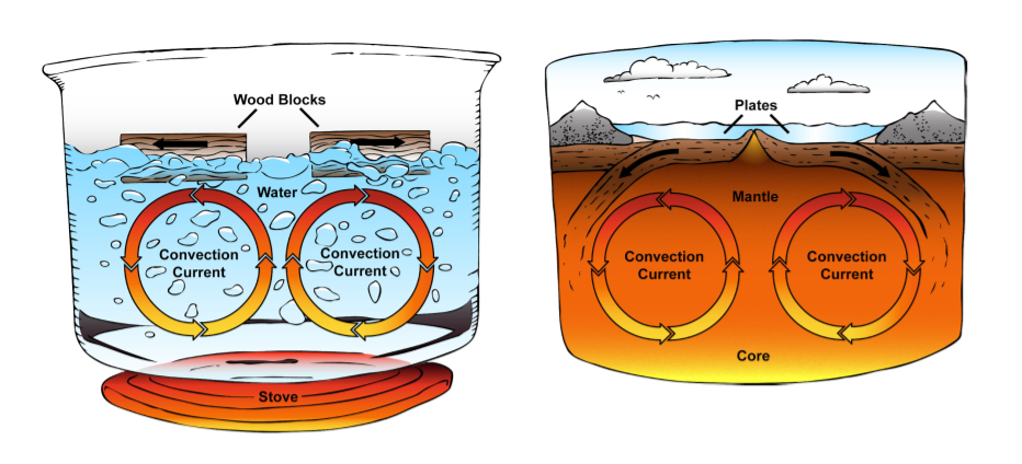
It was at this time realized that the volcanoes and trenches comprised a kind of conveyor belt system, with two complementary mechanisms for creating and retiring crust. Just as wooden blocks are pulled apart when placed in boiling water, continents are pulled apart by convection currents generated by the Earth’s core.
Our ability to use seismographs to record earthquakes was also maturing. You may have heard of the Ring of Fire; a shape along the edge of the Pacific Ocean with higher susceptibility to Earthquakes (I’m looking at you, San Francisco). If you look at a more complete distribution of earthquakes, you can begin to see shapes emerging.
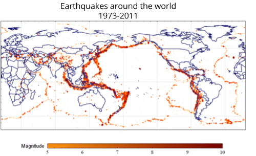
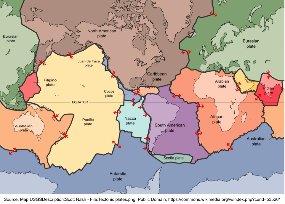
These tiles are tectonic plates. Here is a higher resolution image of plate boundaries.
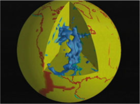
Tectonic plates are not hypotheses; they are physical objects with a history. A good way to appreciate this is by understanding that we can use earthquake measurement instruments to see into the Earth’s interior, in a process not unlike echolocation. Such techniques have been used to figure out the diameter of Earth’s core. They have also revealed fully submerged tectonic plates. These include the Farallon Plate underneath North America, which has not yet been fully reabsorbed by the surrounding mantle.
When rocks are created, they are hot enough to receive an imprint of the Earth’s magnetic field. During WW2, submarines noticed the seafloor was striped: at one location, the magnetic field was pointed North; move a few kilometers west, and the field pointed South. Why the stripes? Separately, evidence emerged for geomagnetic reversals: during the last 83 million years, the Earth’s magnetic field has reversed 183 times. Continental drift and geomagnetic reversals explain the magnetic stripes.
Volcanos, Mountains, and Cratons
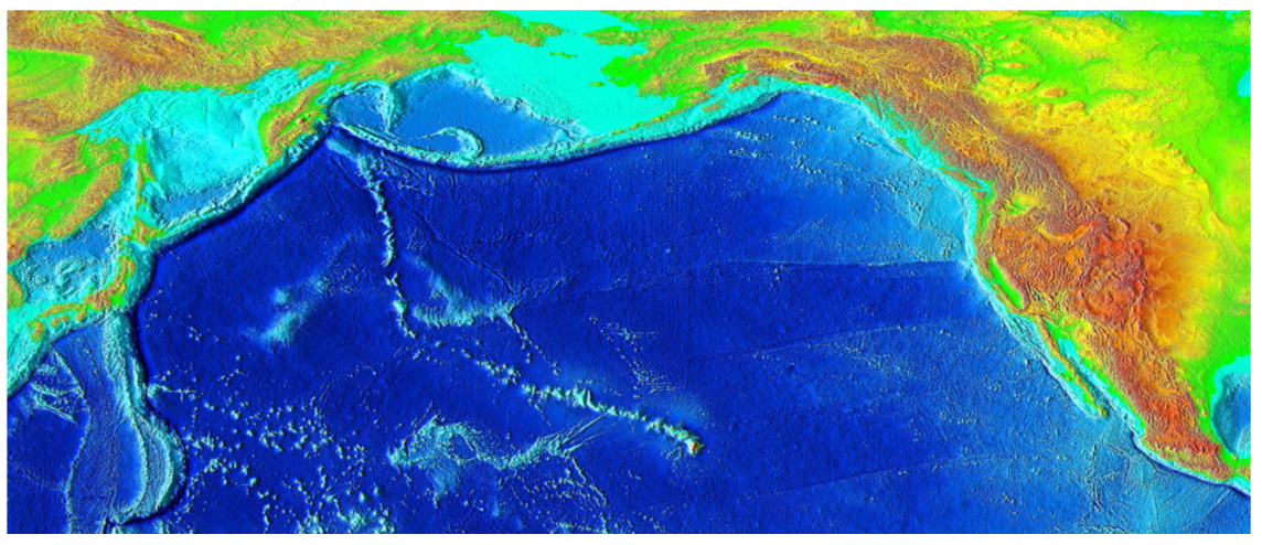
Volcanoes promote seafloor spreading. But not all volcanoes exist at crust boundaries. Consider Hawaii. The fifteen volcanoes that make up the eight islands of Hawaii are the youngest in a chain of more than 129 volcanoes in the Hawaiian-Emperor seamount chain. Note the “V” shaped pattern.
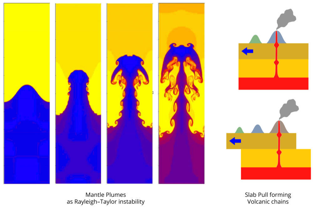
Why is there such a long chain of dormant volcanoes connected to the active volcanoes in Hawaii? The most common explanation is mantle plumes, caused by processes of Rayleigh–Taylor instability. Tectonic plates drag oceanic over these plume-based hotspots, which “poke holes” into the lithosphere. Like fabric in a sewing machine…
Why does this seamont chain “change direction”? Magnetic evidence shows the plates simply changed direction, some 40 million years ago.
Volcanoes create new crust, which is carried along on a conveyor belt, for consumption in the trenches. In this sense, oceanic crust are perpetually being recycled, with the creation of new and the destruction of old crust occurring simultaneously. This explains two salient facts: oceanic crust is much younger and thinner than continental crust.
As a result of this conveyor-like motion, the thin and mobile oceanic crust slowly “squeezes” continental land mass. This is the basis of orogony, the science of mountain formation. It’s fun to think about, especially when you’re traveling across these tremendous landmarks…
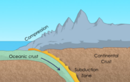
Most mountains are the coastline. Why are the Himalayas closer to the interior? Rather than oceans exerting compressive force on Asia, the Himalayas were formed by the entire subcontinent of India slowly moving North, and ultimately engaging in a slow-motion collision with the Eurasian landmass.
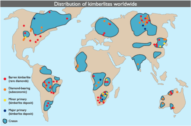
Oceanic crust doesn’t last long before being recycled. Continental crust has a talent for persisting, and growing increasingly thick. Here, the concept of geological province may help. Some continent crust is truly ancient, massive, and deep: these are called cratons. It is primarily in these 2 billion year old rocks that we find kimberlite, the stuff that contains diamonds.
The Supercontinent Cycle
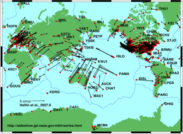
As you can see, there is no room for doubt that continents move. Indeed, GPS is able to detect continental drift in real time (arrows represent the direction and magnitude of drift).
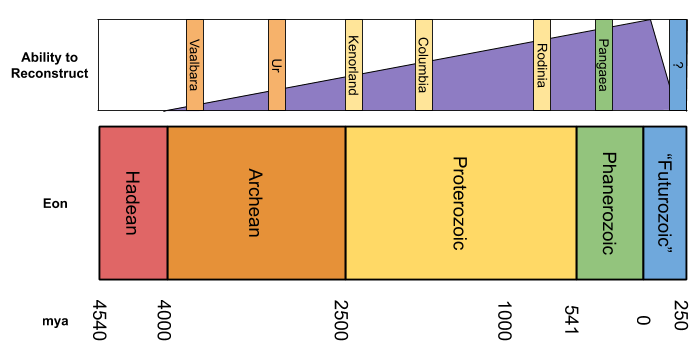
Let’s regroup. We know how the continents are arranged today, and are able to infer some information about other time periods. How much information, exactly?
Looking forward, we have a fairly good idea of what will happen during the next 50 million years. It doesn’t take a rocket scientist to look at the GPS data above and conclude that Africa will collide with Europe, for example. But even though continents move very slowly and predictably on human time scales, after a certain amount of time our models begin to outstrip our data.
Looking backward, we have much more data to use in reverse-engineering previous geological periods. For example, we’ve already seen coastline-matching and mountain ridge evidence suggesting that Africa and South America were adjacent during the reign of supercontinent Pangaea, some 300 million years ago.

Here is a reasonably high-quality animation of continental drift.
So that’s Pangaea. We also have solid evidence for another supercontinent called Rodinia some 700 mya.
Our understanding of these two supercontinents is surprisingly complete. However, our ability to reverse engineer the past becomes less precise (and correspondingly, more controversy-ridden) as you go far beyond 1000 mya. Nevertheless, most geologists think they can make out the existence of four more supercontinents in their data.
Mineralogy provides some evidence for the existence of supercontinents: certain minerals are only formed during these periods. Below is the formation history of molybdenite; similar graphs exist for other minerals. Further, magnetic imprints and radiometry allow us to glimpse the spatial organization or extinct supercontinents.

Why so many supercontinents? Consider again the story of Pangea. It used to be happily unified. But then a transcontinental rift occurred, separating what is now Africa and South America. Rifts occur where convection currents pull apart a single plate, and the in-between land sinks; modern-day rifts exist under the Red Sea, and the East African Rift Valley.
During a supercontinent, there is a single continuous clump of water. After a transcontinental rift, a new ocean forms inside the rift (in our case, the Atlantic). The Atlantic Ocean is growing, the Pacific Ocean is shrinking. This process will continue until the Pacific Ocean is no more. A single ocean, and a single supercontinent. This is the supercontinent cycle.
Biogeography
Animals have been around for some 700 million years. Dead animals sometimes leave behind fossils.
Species are composed of populations: members of a species that live adjacent to one another. These populations tend to occupy a continuous stretch of land. Why? Regardless of where speciation occurs, population have only one way to spread out: walking.
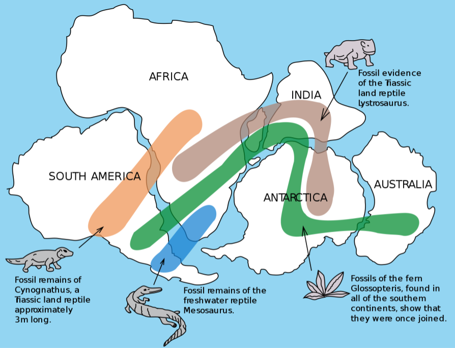
The distribution of fossils starts to make more sense when you recall where the continents existed when these organisms lived.
Continental drift doesn’t just shed light on extinct species, but also living ones. An example to whet your appetite:
Why are marsupial mammals largely confined to Australia? By the time placentas were invented, Australia had separated from Pangaea.
Finally, biogeography is a predictive science: we can use it to make predictions about where to find fossils. Paleontolists can and do consult with geologists to figure out where to look in today’s rocks to find yesterday’s animals. Did you think the transitional form Tiktaalik was found by accident? No: Neil Shubin looked at species on either side of the “gap”, and reviewed when & where they lived. He then interpolated the spacetime location of the transitional forms. By “replayed the clock” to figure out where on contemporary Earth to look: his team went to look at specific strata in Swedish rocks, and the rest is history.
In closing, a few interesting parallels between geology and biology are worth noting:
- Tectonic theory explains continental drift, just as natural selection explains common descent.
- More recently, we can directly observe continental drift with GPS data; just as we can now directly observe speciation.
Takeaways
- Continents move. South America used to be connected to Africa. We can even see continents drift using GPS.
- Continental drift occurs because the Earth’s core is hot, and it creates convection currents that push on tectonic plates above.
- Mountains are created by plates squishing into one another.
- Some volcanos are formed by mantle plumes “poking holes” into otherwise solid plates.
- Ocean crust is “recycled” relatively rapidly. Continental crust persists as cratons.
- Continents regularly coalesce into supercontinents, then dispersal by a transcontinental rift. This is the supercontinent cycle.
- The history of life coexists with continental drift. We can use the Earth sciences to constrain our knowledge of common descent.
